|
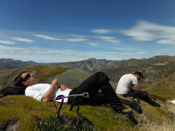
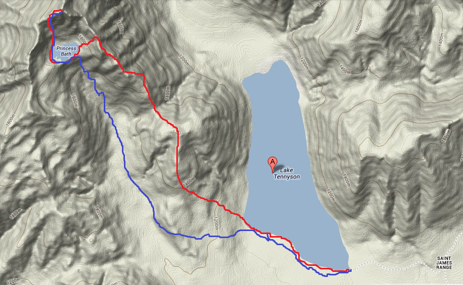
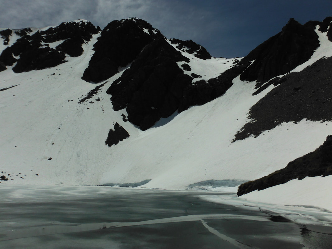
2/5/2018 2 Comments Mt Princess and Princess Bath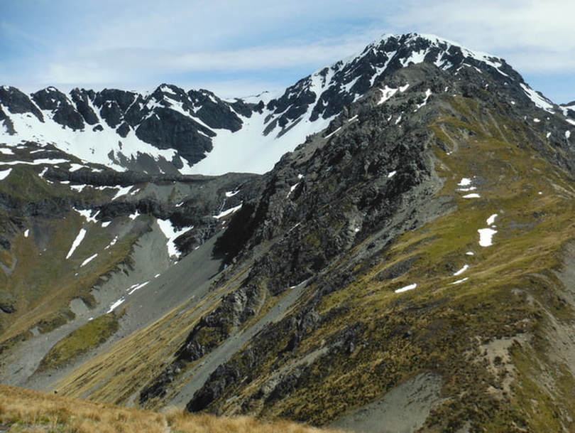 Looking across at Princess Bath Over Jack's Pass from Hanmer Springs and an hour along the bumpy stretch of Tophouse Road lies the banks of Lake Tennyson. This is a great spot for camping in the warmer months and is surrounded by great day walks and overnighters in every direction. We left the car at the camp site on the south-eastern tip of the lake and began our day-long return journey to the peak of Mt Princess. We had chosen to take the route up Mt McCabe from the lake and along the south-eastern ridge although you can attack it from the other side also. We discovered later on you could even walk in from the valley floor and make your way up beside the waterfall straight to the bath if the weather was favourable. The four of us were prepared for a long day and with ice axes in tow and we began our ascent at 9.30am. We had perfect blue skies and warm sunshine as we made our way across a small stream running out of the lake and around the sandy shoreline. In the interest of keeping our boots dry for a few more hours we carried them across and laced up on the far bank. There is no track when you reach Mt McCabe on the far side so we shot for a path up the steep hillside that avoided most of the Matagouri. We were aiming for a section of the ridge where a break in the trees allows an uninterrupted journey to the top. It ended up being steeper than initially thought but once out of the scrub we wandered easily along to the summit of McCabe. This is one of the more achievable parts of the day and took around 2.5 hours from the car moving at a leisurely pace. The sun was well up now and we took a break to cool down and re-hydrate before taking on the next uphill towards Mt Princess. From McCabe we managed the short descent down to a saddle before heading straight into a steep climb on the other side. We were still well below the Bath at this stage and it felt like it was going to be a long day with the summit of Mt Princess hidden behind the ridge. After 20 minutes going straight up we hit snow for the first time. From here the ridge became more difficult to negotiate as the rock is sharp and crumbles off with every second step. There is plenty of room to pick your way along this stretch without worrying about falling but we ended up needing both hands to climb in a few places. Unfortunately some boots came away a little worse for wear in this section as the rock tried to slice straight through to our socks. As we came up over the Bath for the first time and were able to look down onto the water we realised that she was mostly iced over. While there was little snow on the ridge we were standing on, the slopes leading into the Bath were covered all the way to the water. The scree is easy to slide down at this point whereas continuing along the ridge becomes even more challenging. We walked down the first section before glissading into a nice run out near the waterfall. The snow was soft so we had high hopes of an easy final ascent to the summit from the Bath. Some exploring was called for as we tested water temperature - hypothermia inducing, and looked for a little talked about route down from the waterfall to the valley floor. The initial plan was to climb to the top and then retrace our steps back down to the bath and then back up the scree slope to the ridge we had come from. Realising how much extra climbing would be involved we were reasonably keen to find an alternative path that was mostly downhill. After adding some extra layers we made our way around the partially frozen lake to the slope just west of the peak itself. The snow runs all the way to the ridge without hitting any rock from here. The ice axes were all but unnecessary as we sank in almost up to our knees in places. I let the boys kick steps in shifts as my feet are too small to be of much help to them. It was slow going but we kept a steady pace for 45 minutes until hitting the ridge. From here it is much easier to walk along the rocky tops for another 10 minutes until reaching the summit itself. You don't appreciate how much higher the summit is from the Bath until you look back down on it. The Bath is at just over 1700m so the final climb to the top is another 400 vertical to get to the 2126m summit. We took some time to appreciate the view and have a snack before beginning the descent back the way we had come. As with all snow slopes we sent Jeremy down first to test the glissading options and to see if he would stop before hitting the ice covered water below. He made it down in less than 60 seconds and came to an easily controlled stop at least 40m from the edge. With the test dummy safe and well the three of us followed, only having to avoid the odd rock or two near the bottom. Thankfully it was still sunny and warm and our pants dried out in record time. 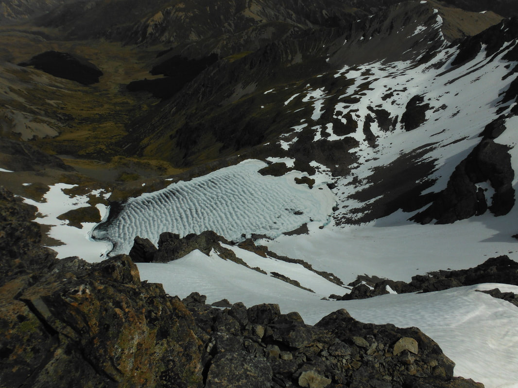 Looking back down at Princess Bath from the summit The waterfall track supposedly has rock cairns to mark the way down but we only found one near where we crossed the waterfall itself. From here we made our way out onto the shingle scree on the south-eastern ridge which allowed us to descend to the stream bed below. This was a steep option for getting down but not difficult to negotiate at a slow pace. The scree isn't great to run on, much more of a controlled slide for the most part. Once in the valley we marched south-east through tall grasses while debating how to get back to the lake. The further we got along the stream the less we wanted to climb over McCabe again so we waited until there was only a small rise between us and the car before turning east again. A gap in the trees allowed us to weave our way across to the lake side and a tramp across swampy land back to the car.
Total trip time - 9.5 hours (5.5 to the summit, 3.5 return via valley) High for the day - 28 degrees Gates to fight over opening on the return trip to Hanmer Springs - 3
2 Comments
|
CategoriesAll Arthurs Pass National Park Avalanche Peak Bealey Spur Bob's Camp Biv Cannibal Gorge Hut Canterbury Foothills Carroll Hut And Kelly Range Cass Saddle Lagoon Saddle Castle Hill Peak Crow Valley And Crow Hut Edwards - Stanley Rivers Fowlers Pass To Lake Guyon Gloriana Peak And Ada Pass Hut Hakatere Conservation Area Hanmer Springs Hope Kiwi Jollie Brook Circuit Kahurangi National Park Kepler Track Lake Sumner Forest Park Lathrop Saddle Little Mt Peel Manuka Hut Marlborough Maukuratawhai Mt Barrosa Mt Bruce Mt Cassidy Mt Potts Mt Princess Mt Somers Mt Tapuae-o-uenuku Mt Te Kinga Mt Torlesse Mystery Lake Nelson Lakes Packhorse Hut Poulter Hut Roys Peak St James Sylvia Tops Tablelands Circuit - Salisbury Lodge The Five Passes The Three Passes Travers-Sabine Circuit Tribulation Hut Waiau Pass And Blue Lake Wanaka West Coast |
 RSS Feed