|
2/5/2018 7 Comments Sylvia Tops - Lewis Pass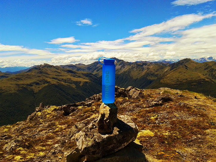 There is nothing quite like having your boss tell you to take a long weekend at the last minute and we wasted no time making plans to head into the hills. The weather was looking good for the Lewis Pass so after changing our minds four or five times, we finally settled on heading up the Nina Valley and traversing across the Sylvia Tops for two nights. The drive out from Christchurch on a hot summer's day was too much for the Corolla's air conditioning but we made it to the Deer Stalkers Hut around 11am. Our intention was to walk into the Nina Hut for lunch before making our way up to Devil's Den Biv in the afternoon. Fitness levels were at an all time low so we had lots of food and a whole lot of time to make our trip over three days. With great weather and full packs we set off onto the Nina Valley track which makes its way along the Nina River from the Lewis Pass road. It starts just past the Deer Stalkers hut and crosses the Lewis River via a swing bridge. The track is well maintained and we kept to a leisurely pace for the first few hours. The DOC time puts the second swing bridge two hours in and the hut a further hour along. All along the track are dotted identical wooden trap boxes - a project being maintained by the Hurunui High School and thankfully all were empty. With the day only getting hotter, the cool of the trees was more welcome than the open grassy banks of the river but we moved quickly through both all the way to the Nina Hut. Having stayed at the tidy 10 bunker before, I was keen to push on to the much cozier (read smaller) Devil's Den Biv on the top of Devilskin saddle. We took on some refreshments and left a note in the intentions book before continuing on our way. The track so far had been less than challenging but we soon hit some fun stuff as we traversed fallen logs and scrambled up steep banks to stay on the track. Although the climb is not considerable, small sections of track require some scrambling where trees have slipped lengthwise down the track or around the upper reaches of the stream. 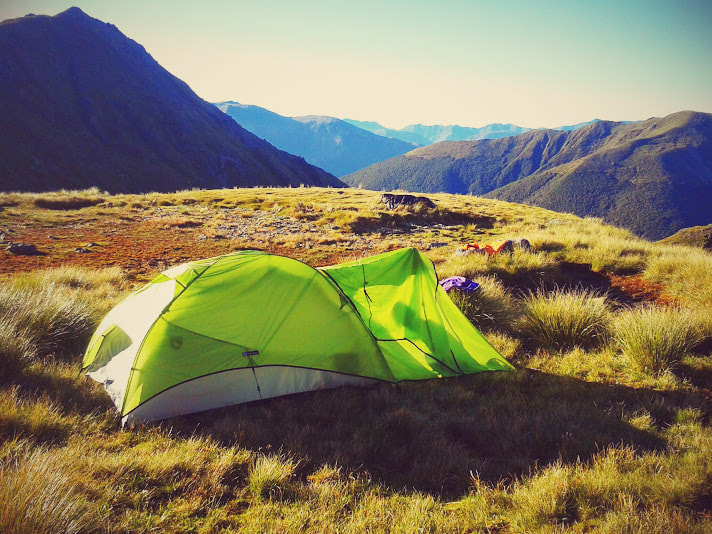 Our campsite up on the tops After popping out at a clearing with a small campfire, the biv came into sight at the crest of the saddle. I think this may have been where the old biv was situated and it would make a great tent site if you found Devil's Den occupied already. Luckily we were the only ones around and we made short work of settling down and cooking dinner in the little two bed hut. Water is a short walk back down the hill and mind the Spaniards don't get you as you reach down to fill your water bottle. Although it was light until 9.30pm, after a delicious freeze-dried delicacy we were already being lulled to sleep by the soft gale force winds hammering the side of the hut. Day two was going to be a bit of a cruise and we started by sleeping in and taking our time over hot coffee. There had been thoughts of climbing the Devil's Rampart but high winds were discouraging us from attempting it on this particular trip. Instead we set to wading our way through dense scrub and up onto the Sylvia Tops. There really is no path here and I lost my companion a few times as we forced our way above the bush line. From here the ridge is a nice steady amble towards point 1625m as the tops slowly revealed themselves towards the east. One of my favourite things about this range is how every point is slightly different. Some are wide and grassy on the approach while others boast rocky outcrops and narrow ridges. With all day to kill, we explored each of them and the many tarns that dot the plateaus just below the main ridge line. Around 3.30pm we found a place to camp just before point 1624m and went in search of water. There was nothing to be seen on the northern side of the saddle but after a little exploration we came across some small pools on the southern side that formed the beginning of a stream which soon disappeared underground. We pitched the tent and spent a relaxing evening watching the sun set over the valley and boiling water from the least murky of the ponds. 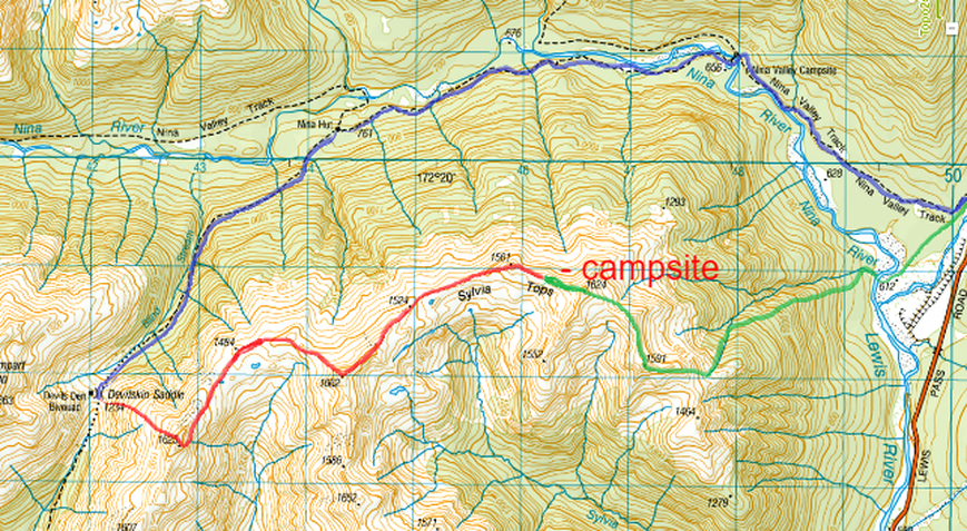 The morning brought more fine and less windy weather as we packed up and got ready for the descent into the Nina River. Having been told that the old DOC track was difficult to find and had the potential to bluff out, we wanted plenty of time to find our way back down. Having not taken a proper topo map (slight oversight) I misjudged the peaks and led us further along the range than initially intended. Instead of dropping down to point 1293m we found ourselves further east at point 1591m. While I considered turning back, the spur we were now facing seemed pretty similar, if not a little less steep and we decided to practice our bush bashing instead. We followed the top of the creek immediately east of 1591m for the first 500m until the sides became too difficult to negotiate. Once in the bush we were able to move a little more freely but it took some serious work to get out of the thick bush and onto what we found was another faint hunting track.
I may have not been Kat's favourite person at this stage but I got some great practice in with my compass as I negotiated the bluffs and found our way down to the river. This section took us several hours due to the number of breaks we took but more experienced bush wanderers would most likely push through in 2-3. We lost and found the track more than twenty times before we broke out onto the banks of the stream once more. This we followed for five minutes until we rock hopped right out onto the Nina herself. A well earned swim was in order as the heat of the day had made for a sticky trek thus far. From here we shot a bearing straight towards the swing bridge at the start of the Nina track. The bush was much easier to move through on this side of the valley and it wasn't long before we were back on a well marked path for the first time in 48 hours. You can also follow the river all the way back to the highway if you prefer. I have mapped our actual trip above and after consulting with my husband who has been the 'right' way down from the tops I would say they were pretty similar. Neither route has an easy to find and/or follow track so take a compass and map to be safe.
7 Comments
|
CategoriesAll Arthurs Pass National Park Avalanche Peak Bealey Spur Bob's Camp Biv Cannibal Gorge Hut Canterbury Foothills Carroll Hut And Kelly Range Cass Saddle Lagoon Saddle Castle Hill Peak Crow Valley And Crow Hut Edwards - Stanley Rivers Fowlers Pass To Lake Guyon Gloriana Peak And Ada Pass Hut Hakatere Conservation Area Hanmer Springs Hope Kiwi Jollie Brook Circuit Kahurangi National Park Kepler Track Lake Sumner Forest Park Lathrop Saddle Little Mt Peel Manuka Hut Marlborough Maukuratawhai Mt Barrosa Mt Bruce Mt Cassidy Mt Potts Mt Princess Mt Somers Mt Tapuae-o-uenuku Mt Te Kinga Mt Torlesse Mystery Lake Nelson Lakes Packhorse Hut Poulter Hut Roys Peak St James Sylvia Tops Tablelands Circuit - Salisbury Lodge The Five Passes The Three Passes Travers-Sabine Circuit Tribulation Hut Waiau Pass And Blue Lake Wanaka West Coast |
 RSS Feed