|
1/31/2018 1 Comment The Five Passes - Queenstown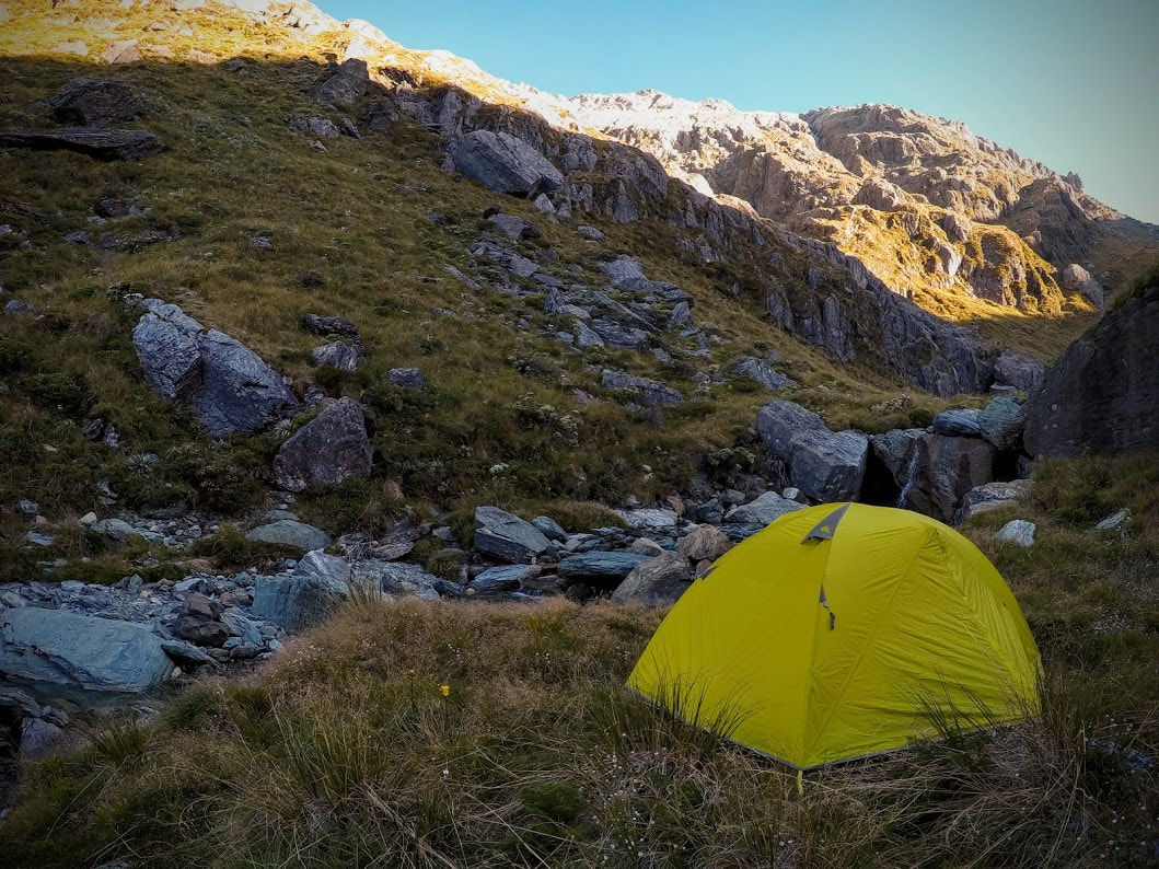
A few years back I read about the Five Passes in a book called "Classic Tramping in New Zealand". At the time I thought that the route was well beyond my physical and navigational capabilities and I wondered if I'd ever be able to manage a trip of that scale. People were taking anywhere between five and ten days to complete the circuit and many had been tent bound for days waiting for inclement weather to pass. This is on top of the fact that there are no huts or even a track for most of the trip. However, it does make its way through one of the most stunning parts of New Zealand and is an absolute must on the tramping bucket list so we couldn't help but give it a good nudge.
We had two weeks off over the summer holidays so after gently persuading the family that we should most definitely have Christmas at my sister's house (conveniently located on the road to Glenorchy) we were ready to go bright and early on Boxing Day. The weather forecast, after looking questionable all week leading up to leaving, miraculously cleared giving us five clear days ahead. Our packing was on the fast and light side of things so no rain for at least the first five days was going to make things much more comfortable. We had ample food for six days which we could stretch to seven or eight if needed but we really weren't sure how long it was going to take heading in. Our combined pack weight came in at 24kg (6kg of this was food) which might be a bit shocking for the traditionalists out there but with all of those passes to climb, a whole five would you believe, we weren't keen on carrying a single item we didn't really need. The drive up to the top of the lake takes about 45min - 1hr from Queenstown depending on tourist traffic and which side of the road they've chosen to drive on that day. Once you reach Glenorchy just follow the signs for the start of the Routeburn and either park at the Routeburn Shelter if you want to start by climbing Sugarloaf or turn off to the Lake Sylvan car park a few kilometres earlier if you want to copy our route. The traditional passes which are completed in either clockwise or anticlockwise (the way we went) direction are as follows: Sugarloaf Pass (1154m) Fohn Saddle (1506m) Fiery Col (1546m) Cow Saddle (1025m) Park Pass (1176m) Most parties start by heading up the Dart and returning through Theatre Flats and I'd suggest that this makes navigation easier on Fohn Saddle and saves your legs a tricky descent down the steeper, more difficult Hidden Falls Creek side of Park Pass. Also, if you want to loop right back to your car you'll end up climbing Sugarloaf twice or you can connect the Routeburn Shelter car park to the Lake Sylvan car park by walking or hitching if you only want to tackle it once.
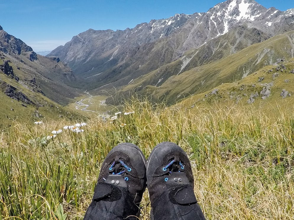
Nine years earlier, on my first foray into the world of tramping with the Otago University PE School, I had climbed Sugarloaf after three days mucking around up the north branch of the Routeburn. The trip triggered in me what has become a lifelong passion for the outdoors but I had no desire to climb that hill twice more so we parked at Lake Sylvan car park instead. This first day was to be by far the biggest with our intended goal the Rock Biv just before Fohn Saddle (roughly 20 - 25km, we didn't GPS this route to save our batteries). Starting on the Lake Sylvan - Rockburn Track is like walking onto a well maintained highway and you should appreciate each and every step as you won't see another path like this for days. The views around the lake are a pretty spectacular introduction to the wilderness in this part of the country and we lapped up the sunshine as we made our way to the shelter on the banks of the Dart river.
It was here that we ran into two fit looking women with big packs who announced that they were training for Godzone and heading in the same direction as us. They had arrived the night before and climbed Sugarloaf before camping on the far side with the intention of also reaching the rock biv that evening. We would spend the next four days running into these two as they charged through rivers and bush with the ease of seasoned professionals carrying extra gear just for the added training benefits. They would catch back up to us later in the day but in the meantime we forded the river easily in front of the shelter and strolled across the grassy flats of the Dart River. There isn't so much of a track here but the terrain is easy to negotiate until you head back into the trees. We followed a mixture of trapping lines and walking track often high into the bush before regaining the river near the confluence with the Beans Burn. We were just rounding the corner of the river, basking in the quiet tranquility of nature when we ran smack bang into 40 tourists in inflatable rafts on the opposite bank. This, coupled with the somewhat incessant drone of jet boats shooting up the Dart River every five minutes was an eloquent example of how different people's experiences of this area can be. This part of the Beans burn was also easy to cross in the wide, shallow section just before the two rivers meet. On the far side you can pick up a track which leads through the bush and down to the bridge. The track then climbs steeply (for just a little longer than you probably want it to) before dropping back down to an open grassy flat beside the river. We had our first break here at 4.5hrs and enjoyed some lunch seasoned with sand fly and a side of sand fly. 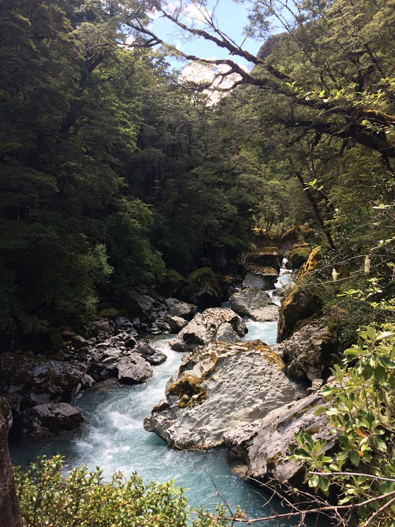
Making our way up the Beans Burn
The track doesn't exactly exist past this point but we found orange markers and an easy to follow route for at least the next 4 hours. It wasn't until just before the clearing south of the rock biv that the way completely disappears near the river. From here you can either try your luck down in the water or crawl along a trapping track that stays on a ledge above the river and spits you out just over a kilometre from the campsite. It's easy going from here but after 10 hours on our feet it still felt like a long way to the monolith down below point 1078. You can stay in the rock biv but we opted to pitch our tent next to the girls who had already set up camp half an hour earlier. Although the way is mostly easy to follow you'll still need a good appreciation for route finding up to here and it's a really long way. Some people choose to get dropped off at the Beans Burn by jet boat or split this section into two days.
In honour of our new fast and light philosophy it was freeze dried cuisine for dinner - this was a bit of a shock to the system as our previous few trips had involved elaborate risottos and mulled wine. We had a good chat with our new acquaintances who as it turn out are not just adventure racers but really quite good ones with a tonne of entertaining stories about doing epic things in epic places. After feeling newly inspired about life in general if not a little humbled by my own mediocre expeditions, we turned in for the night in our brand new tent (it's a similar feeling to putting new socks on I believe, both comforting and deeply satisfying as if all is right with the world). Day two dawned upon some pretty tired bodies but our enthusiasm was heightened by the idea that today would actually involve the climbing of some of the aforementioned five passes. We crossed over the river beside the rock biv and continued up stream for an hour following a mixture of human and game trails and at times just bulldozing straight through the undergrowth. The route up to Fohn Saddle is marked by rock cairns beginning in the stream bed directly below the saddle. We climbed straight up through the tussock to a point just above the 1300m contour. From here we began to sidle to the west before picking up the cairns and working our way around to the saddle. The Pass itself is easy to negotiate and if you want to head to Fohn Lakes stay high and head north east before you begin dropping over the other side where you'll find yourself beneath the bluffs.
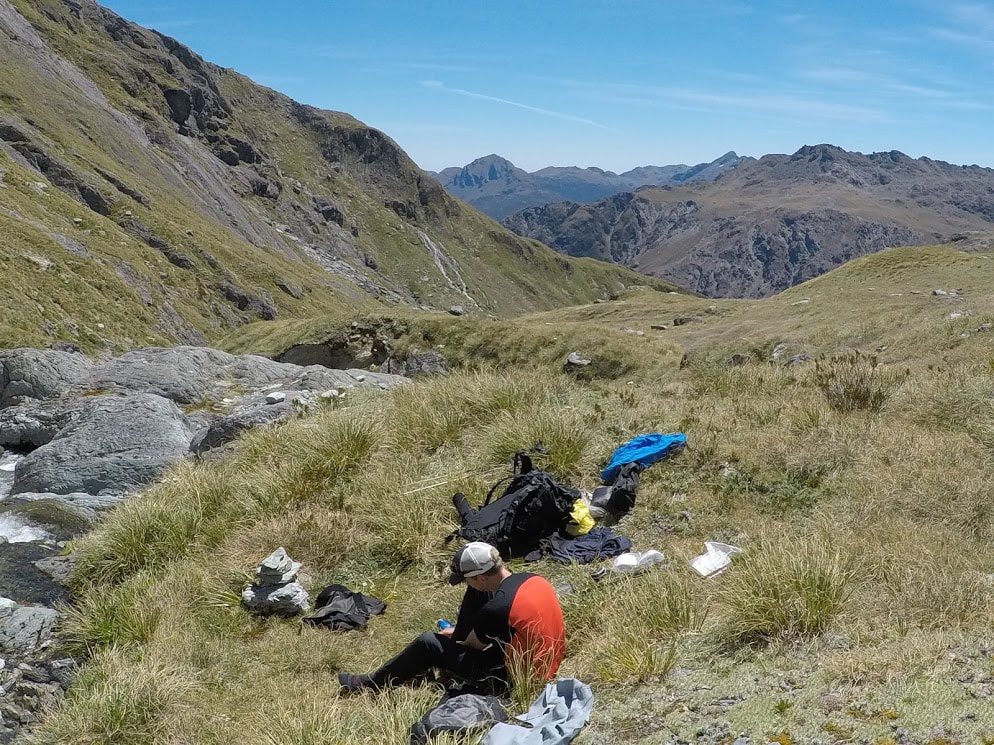
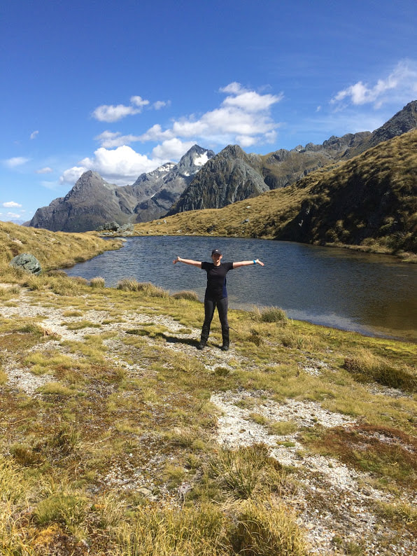
We popped up onto the tops to have a look at the Lakes but continued down from the saddle to meet the river which drops out of Fohn Lake. The two girls had left a little earlier and made it across to the lakes and then out down the river from there - apparently it's a little technical to begin with and definitely steeper than our more leisurely path directly beneath the saddle. We were experiencing a scorcher of a day so upon gaining the river we took a long break to swim and consume large amounts of Salami and Camembert. We followed the river down mostly on the north side and eventually picked up a bit of a track as it gorged dramatically on the way out to the Olivine Ledge. Follow the spur on the true right of the river until you reach the shelf which marks your path to Fiery Col. This is open swampy terrain and easy to move quickly through with cairns still placed sporadically throughout. Cross the bigger river (starts south of point 1517 heading NW) at around 1130m where rock cairns mark both sides of the gorge.
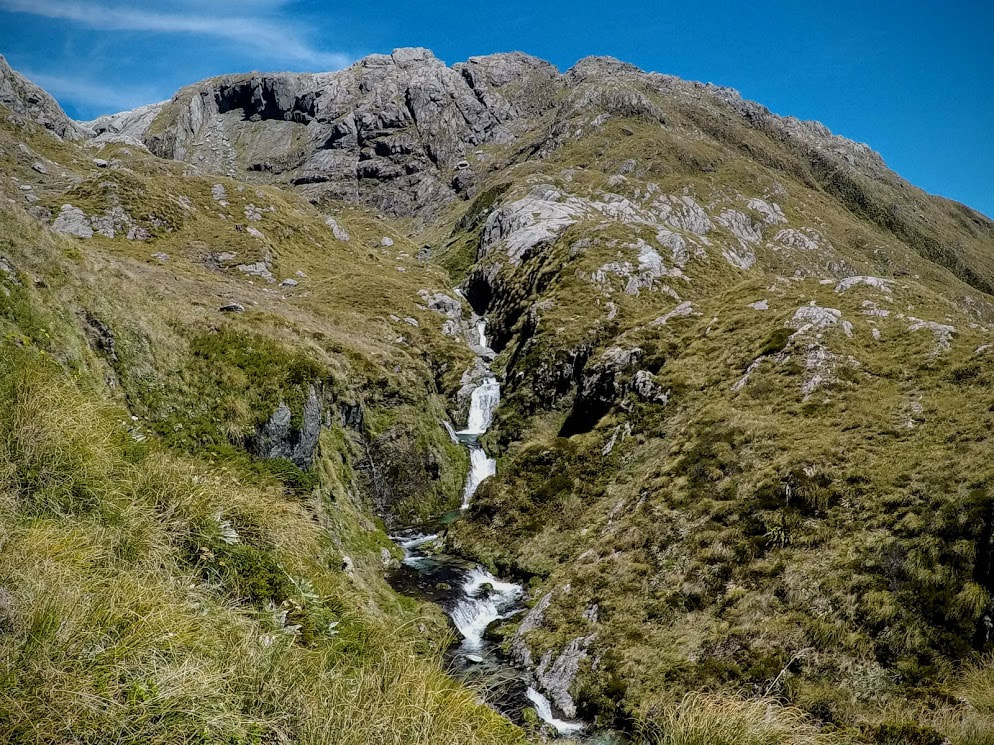
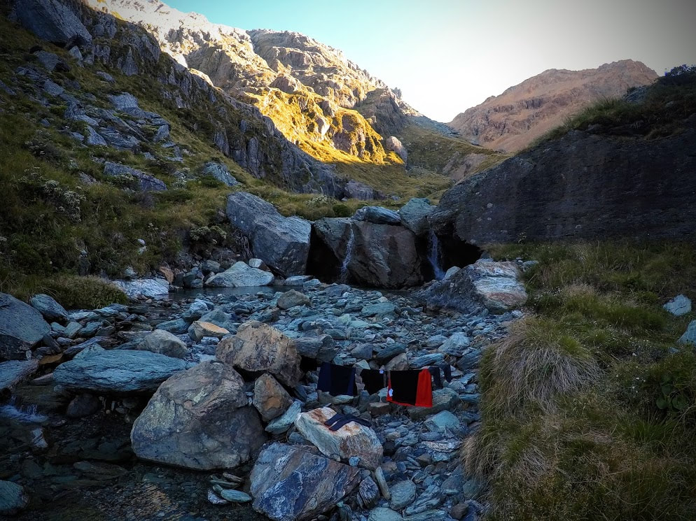
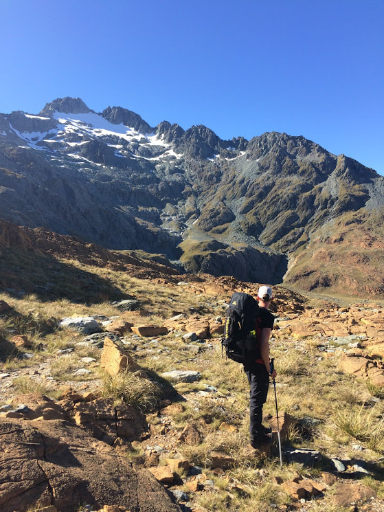
The legs weren't fully recovered from the previous day so we decided to camp just below Fiery Col rather than crossing it and having to find somewhere to pitch a tent on the other side. We found a cracker little spot with a double waterfall and perfectly sized tent platform to relax in the afternoon sun. It was 7 hours total for the day and plenty of time to get some washing done before bedtime. After sleeping for near on 12 hours we were up reasonably early and straight into the climb to Fiery Col. Having already gained some height the previous day it only took 45 mins to find the top of the Col between the large boulders. On the far side it was decidedly rockier with a few patches of snow but easy to pick your way down with nice steady to walk on scree.
We just spotted the girls again in the distance as we began our descent. They had camped a little higher up the river than us the night before but close enough that we were both harassed awake in the morning by the same cheeky Kea. Again the cairns are plentiful as you pick your way down and around towards Cow Saddle. The route stays high on the spur dropping down beside some more (there's a lot on this trip) majestic looking waterfalls. Once on the flats there is some easy walking over to Cow Saddle which although boggy in places has many spots that would be fine to tent despite what we had read before getting there. A distinct track works its way along the west side of Hidden Falls Creek before crossing the river and entering the bush on the other side. There is a great campsite in the clearing one river prior to where you turn to go up to Park Pass if you're thinking of stopping around here. We made our way a few hundred metres past the creek immediately below Park Pass to where the track begins to head up the spur to the south of it.
This is an awesomely steep route and definitely gets the heart rate up as you practice step ups over and over again. While it's still track-like I'm glad I was going up rather than down as there are some fun tree ladders every few metres that would make the going slow if you're not super sure footed. We were almost at the top of the bush line when we ran into the first new people we had seen in three days. A family heading in the opposite direction who had walked up from Theatre Flat that morning and were looking at camping somewhere in Hidden Falls. After exchanging all of the appropriate pleasantries we managed the last of the climb out onto the tussock. We didn't actually find the track again from here and just took a straight line to the top of the Pass instead. 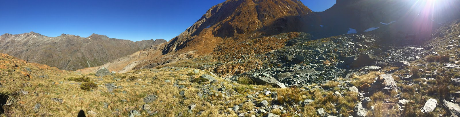
Descending Fiery Col
There had been plans earlier in the week to make the side trip around to Lake Nerine but it was a bit too tempting to head back to Queenstown for beer and pizza so naturally we dropped into the valley and headed towards Theatre Flat. The route down off the Pass was actually much more well defined than what we picked our way through further down. It wasn't until we hit the bush again that we started to pick up the old orange triangles again. My feet were pretty sore but we had hours of daylight left so we stopped for an early dinner and a break before tackling the last few clearings and point 908 which is a bigger climb than it looks on the map. When we finally arrived at Theatre Flat we were overwhelmed with groups camped everywhere and low and behold our adventure buddies set up right beside the track out. They had been a bit faster than our 11 hours and still had days of walking planned whereas we were definitely going to be out the next day.
Now that we were down off the tops we experienced the full force of the sand flies as we tried to make coffee and talk without swallowing too many of them. There was a good amount of story swapping and some bewilderment at how many glowing flames were out in the clearing with the total fire ban in place. In the morning the girls were already gone, the last we saw of them for the trip, and we packed the tent up quickly to escape the blood sucking swarms. Now that we were on a proper track the speed picked up significantly all the way to the turn off to Sugarloaf. This last pass is a short but sharp ascent onto a wide open saddle which drops steadily on the far side to the Routeburn Track. The number of people we began to encounter increased proportionately to our proximity with the Routeburn and unfortunately none of them looked quite as disgusting as we now felt. I distinctly smelt perfume on one girl wandering past. It was 5.5 hours from Theatre Flat out to the Routeburn Car Park and then another hour along the road back to Lake Sylvan Car Park. Day One: 10 hours 45 mins Lake Sylvan to Rock Biv Day Two: 7 hours Rock Biv to Fiery Col via Fohn Saddle Day Three: 11 hours 30 mins Fiery Col to Theatre Flat via Cow Saddle and Park Pass Day Four: 6.5 hours Theatre Flat to Lake Sylvan Car Park via Sugarloaf Downloadable Trip Notes
1 Comment
11/4/2022 09:55:19 am
sdchanks for sharing the article, and more importantly, your personal experience of mindfully using our emotions as data about our inner state and knowing when it’s better to de-escalate by taking a time out are great tools. Appreciate you reading and sharing your story since I can certainly relate and I think others can to Leave a Reply. |
CategoriesAll Arthurs Pass National Park Avalanche Peak Bealey Spur Bob's Camp Biv Cannibal Gorge Hut Canterbury Foothills Carroll Hut And Kelly Range Cass Saddle Lagoon Saddle Castle Hill Peak Crow Valley And Crow Hut Edwards - Stanley Rivers Fowlers Pass To Lake Guyon Gloriana Peak And Ada Pass Hut Hakatere Conservation Area Hanmer Springs Hope Kiwi Jollie Brook Circuit Kahurangi National Park Kepler Track Lake Sumner Forest Park Lathrop Saddle Little Mt Peel Manuka Hut Marlborough Maukuratawhai Mt Barrosa Mt Bruce Mt Cassidy Mt Potts Mt Princess Mt Somers Mt Tapuae-o-uenuku Mt Te Kinga Mt Torlesse Mystery Lake Nelson Lakes Packhorse Hut Poulter Hut Roys Peak St James Sylvia Tops Tablelands Circuit - Salisbury Lodge The Five Passes The Three Passes Travers-Sabine Circuit Tribulation Hut Waiau Pass And Blue Lake Wanaka West Coast |
||

 RSS Feed