|
6/17/2018 2 Comments Edwards - Stanley Rivers, St James Pool Hut on our third night In October 2012 we took on the rather daunting (at least it felt that way at the time) task of walking part of the St James cycle trail from the Edwards River to Lake Guyon via the Stanley River and returning along the west face of Mt Maria. This incredibly picturesque track is located a short drive north from Hanmer Springs over Jacks Pass. We arrived just as night was falling and left our car at the locked gate a couple of kilometres past the turn off to the ski field. With head torches in place and no idea how long it would take to get to our tent site for the night, we donned packs and got moving. The four wheel drive track was dry and easy to walk on as we made our way steadily up the Edwards River. Our destination was Cow Stream, a small river around 10km up the valley which was rumoured to have some impressive hot springs. Scotties, a small 4 bunk hut, lies less than 30 minutes further in, under the shadow of Mt Douglas. We were gambling on the pools being worth a night in our tiny, two man tent and we weren't disappointed. When we reached the river we found two concreted in pools, bubbling with hot water, below a grassy plateau perfect for the tent. A few tea light candles around the main pool created some ambiance and we settled in to soak our legs after a solid evening stroll. 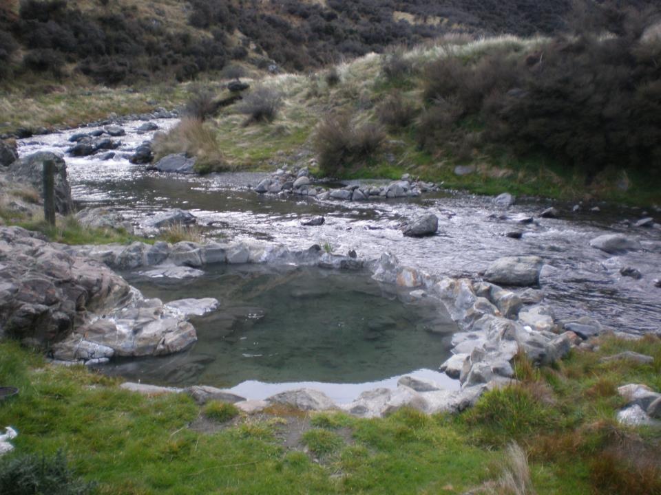 These are totally worth a slight detour off the track The next day dawned warm and clear along with a million sand flies ready for their breakfast. We decamped at the speed of sound and were marching down to the river at quite a reasonable hour. We stopped at Scotties only to refill our water bottles and made our way gingerly across the river before Charlie's Hill. The water was quite swift and my new trekking poles got their first real work out standing up to the knee-high torrent. From here we trudged up and over Charlie's saddle and onto the Racecourse. This wide, swampy plain looks like a walk in the park but takes a good hour to cross. From here we dropped down onto the single track which follows the Stanley River all the way to Lookout Hill. We lost the track for some time around here and simply followed the river until we finally sited Stanley Vale Hut. This two bedroom, historic, abode is an awesome place to stay with beautiful views and plenty of room for cooking and drying clothes. Unfortunately we hadn't made it there first, meaning a short stop for food was all we could afford before pushing on again. We were counting on making it to Lake Guyon and staying in the DOC hut instead but a dozen hunters, their trucks and dogs had the place fairly overrun. Tired and a little disappointed with another night in the tent we set up camp a little further around the lake after a solid 10 hours on our feet. With the rain setting in we cooked a quick dinner of mystery foiled delights from the local Indian store (we've never tried this again!) before drifting off to sleep beside the water's edge. It must have rained heavily all night because when we woke in the morning the lake level had risen and the track had turned into a fast flowing stream in most places. The soaking tent was strapped to the back of Jeremy's pack and we made light work of a bowl of porridge before leaving camp. As soon as we started walking we began to appreciate the amount of water that was pouring off the hills. Streams ran everywhere across the track and mini waterfalls had appeared in the middle of paddocks as we passed. We skirted around the top of the lake and made our way west again to meet the Waiau River in all of its flooded glory. 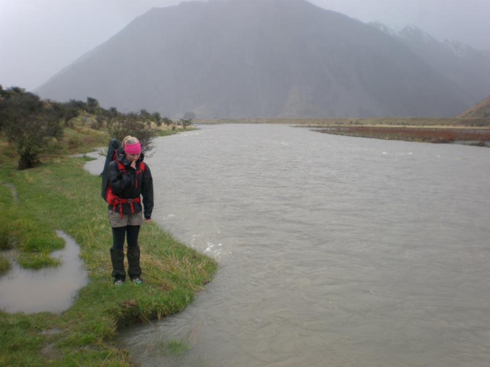 This is me standing on the track... The rain continued to saturate us as we turned south and headed along the river bank towards Pool Hut, our intended destination for the night. Water engulfed the track and in places the river was so close to washing over it I could have been swept down stream with a badly placed foot step. We made good time all the way to Little Lake where we found some discrepancies between the track and our map. With the new trail just recently built, the route to the bridge is now somewhat changed to the old one on the map. Preferring to rely on my own navigation skills we took off cross country and cut a path through The Downs until we found the new bridge location just around the corner from where it was on our map (2010 edition). However, if your route finding skills are a little basic I would recommend just following the new track around and back down to the river. Especially if your map is pre-2011 as things are not quite as they seem - including the exact location of the bridge. After crossing over the swollen river we had a steep climb up Saddle Spur before making our way back down onto the flats. The track was in really good condition but the constant stream crossings became more and more nerve racking as we closed the gap between us and Pool Hut. By the time we reached Dumpy Stream the first thunder clap reverberated around the surrounding mountains. Heads down, we powered as fast as we could in the direction of the hut. The last stream crossing was the worst with both of us using the poles and each other to wade through the raging waters. When we reached Pool Hut the storm was in full force and we dove gratefully through the door into the dry interior. DOC had beaten us to the fire and removed it leaving in its place a dirty mink blanket from the Warehouse that was hanging in the rafters. Usually I wouldn't touch such an item with a stick but after weighing up my options I decided hypothermia was scarier than the manky dolphin blanket. It added some cosy insulation to my sleeping bag as we snuggled into some warm clothes and took a much needed nap. 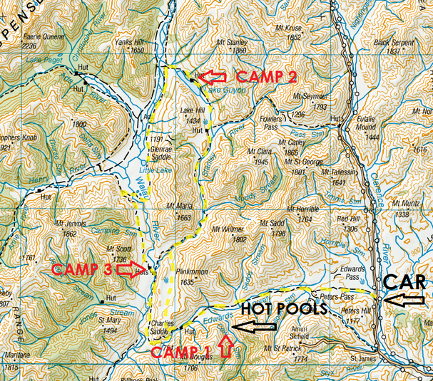 It had taken around 7 hours to reach Pool Hut from Lake Guyon and we slept pretty well that night. The morning brought the added element of a dumping of snow from overnight but we were determined to be back in Christchurch at a reasonable hour regardless. Breakfast consisted of several hot drinks as we drew courage from our coffee to face the freezing outside temperatures. We left bright and early and made our way down past Old Bridge Hut of the no walls historic hut persuasion. Over McArthur Bridge we made our way back to Scotties and the familiar Edwards River. It took a lot longer finding a safe place to cross but meandered our way back up stream towards the waiting car. The walk out was a long one, especially when you hit the rise where Peter's Valley Track splits in two directions and have to trudge up hill for half an hour. We kept up a steady pace and finally sited the car late afternoon.
While it was mostly easy tramping the whole four days, the distances we covered would only be enjoyed with a good level of fitness. To find the hot pools you need to follow the track until you hit Cow Stream where you turn left and head up the hill until you run out of flat land. The pools are a short walk down from here but there are plenty of tracks to follow once you find the right area.
2 Comments
|
CategoriesAll Arthurs Pass National Park Avalanche Peak Bealey Spur Bob's Camp Biv Cannibal Gorge Hut Canterbury Foothills Carroll Hut And Kelly Range Cass Saddle Lagoon Saddle Castle Hill Peak Crow Valley And Crow Hut Edwards - Stanley Rivers Fowlers Pass To Lake Guyon Gloriana Peak And Ada Pass Hut Hakatere Conservation Area Hanmer Springs Hope Kiwi Jollie Brook Circuit Kahurangi National Park Kepler Track Lake Sumner Forest Park Lathrop Saddle Little Mt Peel Manuka Hut Marlborough Maukuratawhai Mt Barrosa Mt Bruce Mt Cassidy Mt Potts Mt Princess Mt Somers Mt Tapuae-o-uenuku Mt Te Kinga Mt Torlesse Mystery Lake Nelson Lakes Packhorse Hut Poulter Hut Roys Peak St James Sylvia Tops Tablelands Circuit - Salisbury Lodge The Five Passes The Three Passes Travers-Sabine Circuit Tribulation Hut Waiau Pass And Blue Lake Wanaka West Coast |
 RSS Feed